Bild 1 von 7


Galerie
Bild 1 von 7
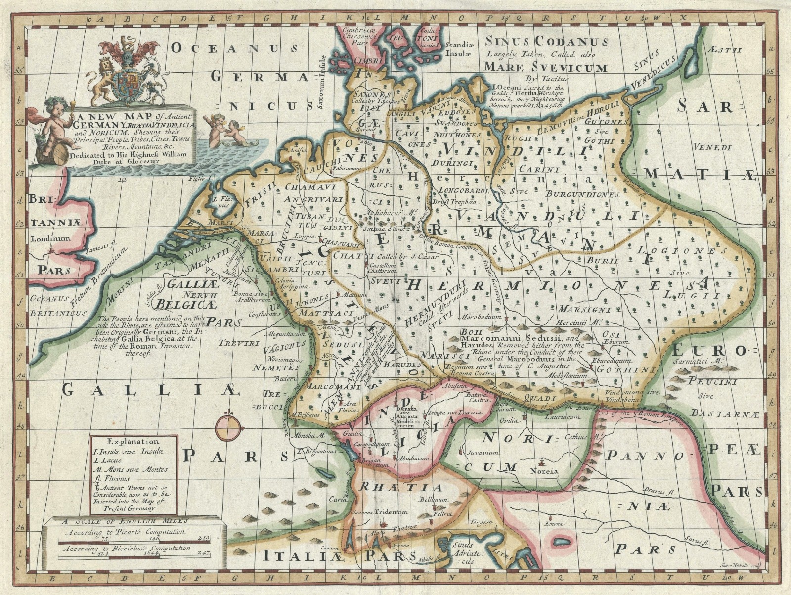


Landkarte "Eine neue Karte des antiken Deutschlands,Rätien,Vindelicia und Nordicum" Brunnen,1700-

£200,00
Ca.EUR 230,14
oder Preisvorschlag
Artikelzustand:
- Sofort-KaufenLandkarte "Eine neue Karte des antiken Deutschlands,Rätien,Vindelicia und Nordicum" Brunnen,1700
Oops! Looks like we're having trouble connecting to our server.
Refresh your browser window to try again.
Versand:
£18,00 (ca. EUR 20,71) International Tracked Postage.
Standort: London, Vereinigtes Königreich
Lieferung:
Lieferung zwischen Mi, 10. Sep und Do, 25. Sep nach 94104 bei heutigem Zahlungseingang
Rücknahme:
Keine Rücknahme.
Zahlungen:
Sicher einkaufen
- Gratis Rückversand im Inland
- Punkte für jeden Kauf und Verkauf
- Exklusive Plus-Deals
Der Verkäufer ist für dieses Angebot verantwortlich.
eBay-Artikelnr.:336059609575
Artikelmerkmale
- Date Range
- 1700-1799
- Antique
- Yes
- Type
- Physical Map
- Format
- Sheet Map
- Printing Technique
- Copper Plate
- Year
- 1700
- Era
- 1700s
- Cartographer/Publisher
- Edward Wells
- Original/Reproduction
- Antique Original
- Country/Region
- Germany
Artikelbeschreibung des Verkäufers
Rechtliche Informationen des Verkäufers
CRN: 07952137
Info zu diesem Verkäufer

map2map
100% positive Bewertungen•731 Artikel verkauft
Angemeldet als gewerblicher Verkäufer
Beliebte Kategorien in diesem Shop
Verkäuferbewertungen (306)
- e***2 (1304)- Bewertung vom Käufer.Letzte 6 MonateBestätigter KaufExquisite 18th century depiction and gravure of the legendary Bastille by one of the greatest artists of the period and the engraver. Offered at a price point which was generous and more than affordable. This gravure was professionally, expertly packaged—which is a distinct pleasure. It is always pleasing to deal with a professional business in antiquities, as they possess the knowledge in handling fragile, irreplaceable, historical art. Sent securely by Fedex, arriving very quickly. RecommendedAntique Print "A View of the Bastile at Paris" (Bastille) Rigaud, 1749 (Nr. 335814097225)
- f***5 (5)- Bewertung vom Käufer.Letzte 6 MonateBestätigter KaufQuickly shipped, very well packaged with supporting internal card and plastic. As described and in good condition. Thank you once more. Comes once more with a certificate of authenticity, which is very much appreciated. This is my second map from this gallery and probably won't be the last. Highly recommended.Map "Southern Alps of New Zealand" Royal Geographical Society, 1910 (Nr. 334963326798)
- u***i (150)- Bewertung vom Käufer.Letzte 6 MonateBestätigter KaufItem as described. Packed well with fast shipping. In good condition for its age! Would buy from this seller again.Antique Map "Carta delle Isole Pelew" (Palau/Philippines) Anon, c.1790 (Nr. 335166770898)
Noch mehr entdecken:
- Karten für Deutschland,
- Vor 1700 Antike Porzellan-, Teller,
- Vor 1700 Antike Porzellan-, Vasen,
- Atlant & Landkarte für Deutschland,
- Vor 1700 Antike Porzellan-, Figuren,
- Vor 1700 Keramik Antike Porzellan-, Krüge,
- Atlanten und Politische Landkarten von Deutschland,
- Vor 1700 Porzellan Antike Porzellan-, Keramik- & Glaswaren,
- Prepaid SIM-Karten Deutschland,
- Vor 1700 Keramik Antike Porzellan-, Keramik- & Glaswaren
Beliebte Kategorien in diesem Shop
Verkäuferbewertungen (306)
- e***2 (1304)- Bewertung vom Käufer.Letzte 6 MonateBestätigter KaufExquisite 18th century depiction and gravure of the legendary Bastille by one of the greatest artists of the period and the engraver. Offered at a price point which was generous and more than affordable. This gravure was professionally, expertly packaged—which is a distinct pleasure. It is always pleasing to deal with a professional business in antiquities, as they possess the knowledge in handling fragile, irreplaceable, historical art. Sent securely by Fedex, arriving very quickly. RecommendedAntique Print "A View of the Bastile at Paris" (Bastille) Rigaud, 1749 (Nr. 335814097225)
- f***5 (5)- Bewertung vom Käufer.Letzte 6 MonateBestätigter KaufQuickly shipped, very well packaged with supporting internal card and plastic. As described and in good condition. Thank you once more. Comes once more with a certificate of authenticity, which is very much appreciated. This is my second map from this gallery and probably won't be the last. Highly recommended.Map "Southern Alps of New Zealand" Royal Geographical Society, 1910 (Nr. 334963326798)
- u***i (150)- Bewertung vom Käufer.Letzte 6 MonateBestätigter KaufItem as described. Packed well with fast shipping. In good condition for its age! Would buy from this seller again.Antique Map "Carta delle Isole Pelew" (Palau/Philippines) Anon, c.1790 (Nr. 335166770898)