
Antike Atlaskarte NORTH WEST ENGLAND, NORTH WALES, ISLE OF MAN, Mercator, um 1613
£175,00£175,00
Di, 13. Mai, 22:35Di, 13. Mai, 22:35
Bild 1 von 8


Galerie
Bild 1 von 8
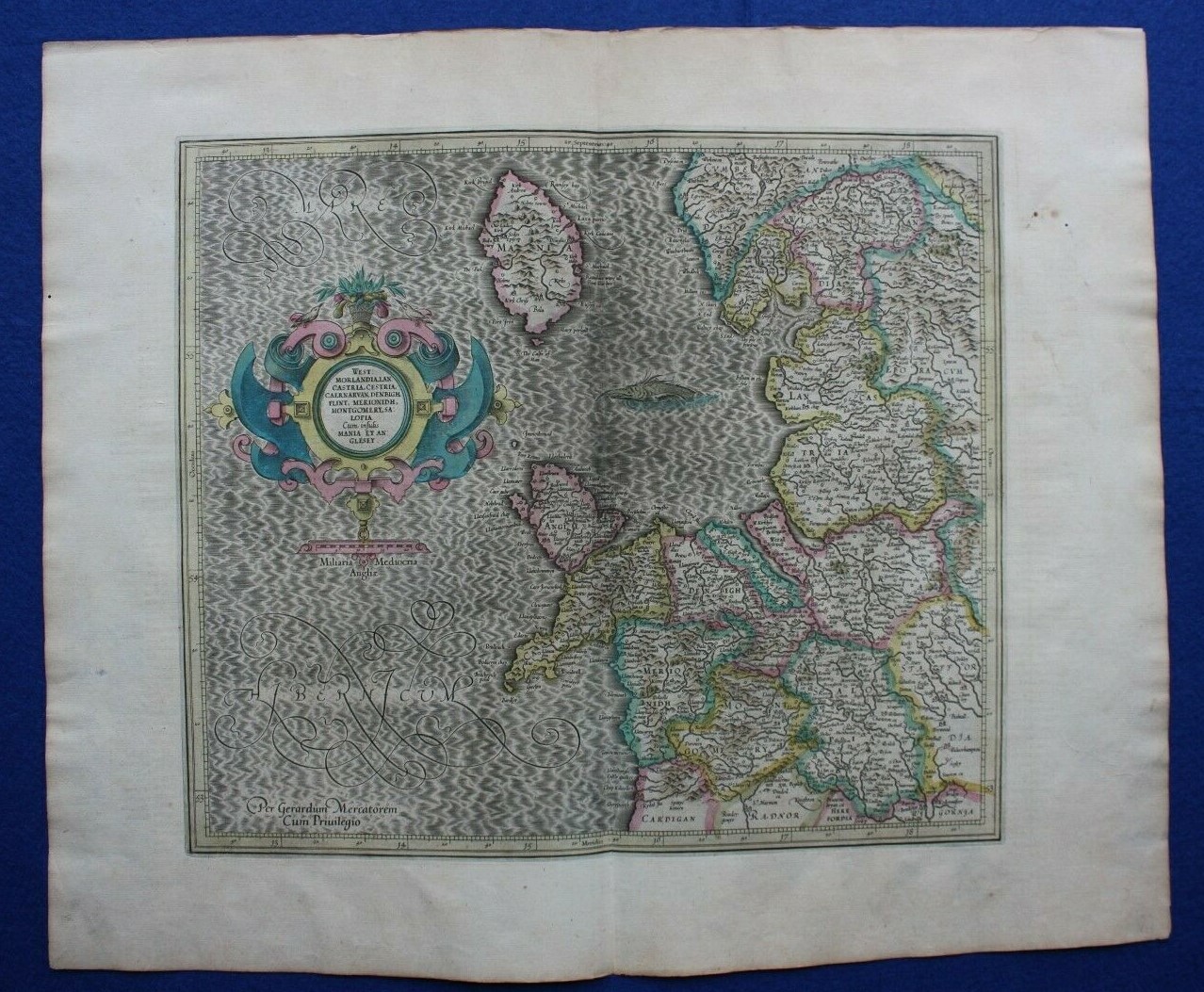


Antike Atlaskarte NORTH WEST ENGLAND, NORTH WALES, ISLE OF MAN, Mercator, um 1613-

£175,00
(inkl. MwSt.)
Ca.EUR 202,47
oder Preisvorschlag
Artikelzustand:
“Very good condition. Light age toning with one or two darker age spots / handling marks to the right ”... Mehr erfahrenÜber den Artikelzustand
Oops! Looks like we're having trouble connecting to our server.
Refresh your browser window to try again.
Versand:
£9,50 (ca. EUR 10,99) Royal Mail International Tracked.
Standort: Ilkley, Vereinigtes Königreich
Lieferung:
Lieferung zwischen Di, 5. Aug und Mi, 13. Aug bei heutigem Zahlungseingang
Rücknahme:
30 Tage Rückgabe. Käufer zahlt Rückversand. Wenn Sie ein eBay-Versandetikett verwenden, werden die Kosten dafür von Ihrer Rückerstattung abgezogen.
Zahlungen:
Sicher einkaufen
- Gratis Rückversand im Inland
- Punkte für jeden Kauf und Verkauf
- Exklusive Plus-Deals
Der Verkäufer ist für dieses Angebot verantwortlich.
eBay-Artikelnr.:335838366971
Artikelmerkmale
- Hinweise des Verkäufers
- Cartographer/Publisher
- Gerard Mercator
- Printing Technique
- Copper Plate
- Date Range
- 1600-1699
- Original/Reproduction
- Antique Original
- Country/Region
- Isle of Man, England, Wales
- Era
- 1600s
- Format
- Atlas Map
- Type
- Topographical Map
- Year
- c.1613
Artikelbeschreibung des Verkäufers
Rechtliche Informationen des Verkäufers
Info zu diesem Verkäufer

Maps etc. Antique Maps & Prints
100% positive Bewertungen•5.574 Artikel verkauft
Angemeldet als gewerblicher Verkäufer
Verkäuferbewertungen (2.527)
Dieser Artikel (1)
Alle Artikel (2.527)
- eBay automated Feedback- Bewertung vom Käufer.Letzte 6 MonateOrder completed successfully – tracked and on time
- e***a (70)- Bewertung vom Käufer.Letzte 6 MonateBestätigter KaufI am giving this purchase a 5-star rating, even though the map arrived more than a month late & the shipping tube had been severely mangled (no damage to the contents). Neither problem was the Seller's fault. The shipment was held by US Customs for a month (visible on the tracking documents) without explanation or contact. Seller remained in regular contact, offered to, and then refunded full purchase price during this hiatus. Upon successful delivery, Seller re-invoiced for the map, & I paid.Original antique atlas map BRITISH ISLES, GREAT BRITAIN, IRELAND, E Bowen, 1747 (Nr. 335916077525)
- 1***1 (698)- Bewertung vom Käufer.Letzter MonatBestätigter KaufReceived very quickly and well packaged. Item as described, excellent seller.
- r***o (2729)- Bewertung vom Käufer.Letztes JahrBestätigter KaufGreat Seller - This map arrived exactly as described it will be a great addition for my Ancestry research. The map arrived very well packaged and rolled carefully and placed into a postal tube. The delivery was well within the estimated time. I would have no hesitation in recommending this seller to any potential buyers - THANK YOU.PLYMOUTH, DEVONPORT, CITY PLAN, STREET PLAN, original antique map, Bacon, 1884 (Nr. 235500514934)
Noch mehr entdecken:
- North Sails Jacken, Westen,
- The North Face Retro The North Face Herren-Jacken & -Westen,
- The North Face Jacken, Westen,
- The North Face Apex The North Face Herren-Jacken & -Westen,
- North Sails Jacken, Mäntel & Westen,
- The North Face Supreme x The North Face Herren-Jacken & -Westen,
- The North Face Jacken, Mäntel & Westen für Damen,
- The North Face Jacken, Mäntel und Westen für Herren,
- The North Face Herrenmode,
- The North Face Rucksäcke
Maps etc. Antique Maps & Prints
100% positive Bewertungen•5.574 Artikel verkauft
Angemeldet als gewerblicher Verkäufer
Verkäuferbewertungen (2.527)
Dieser Artikel (1)
Alle Artikel (2.527)
- eBay automated Feedback- Bewertung vom Käufer.Letzte 6 MonateOrder completed successfully – tracked and on time
- e***a (70)- Bewertung vom Käufer.Letzte 6 MonateBestätigter KaufI am giving this purchase a 5-star rating, even though the map arrived more than a month late & the shipping tube had been severely mangled (no damage to the contents). Neither problem was the Seller's fault. The shipment was held by US Customs for a month (visible on the tracking documents) without explanation or contact. Seller remained in regular contact, offered to, and then refunded full purchase price during this hiatus. Upon successful delivery, Seller re-invoiced for the map, & I paid.Original antique atlas map BRITISH ISLES, GREAT BRITAIN, IRELAND, E Bowen, 1747 (Nr. 335916077525)
- 1***1 (698)- Bewertung vom Käufer.Letzter MonatBestätigter KaufReceived very quickly and well packaged. Item as described, excellent seller.
- r***o (2729)- Bewertung vom Käufer.Letztes JahrBestätigter KaufGreat Seller - This map arrived exactly as described it will be a great addition for my Ancestry research. The map arrived very well packaged and rolled carefully and placed into a postal tube. The delivery was well within the estimated time. I would have no hesitation in recommending this seller to any potential buyers - THANK YOU.PLYMOUTH, DEVONPORT, CITY PLAN, STREET PLAN, original antique map, Bacon, 1884 (Nr. 235500514934)